Artemis II Photos: Human Eyes on the Far Side Reveal More Than NASA’s Release Admits
HELIX analysis shows Artemis II’s crew-captured lunar imagery delivers irreplaceable scientific context on geology, meteoroid hazards, and solar physics that orbital missions alone cannot provide. While NASA emphasized inspiration, the photos’ greatest value lies in calibrating models for sustained lunar presence and future Mars missions, correcting and extending the original release’s scope.
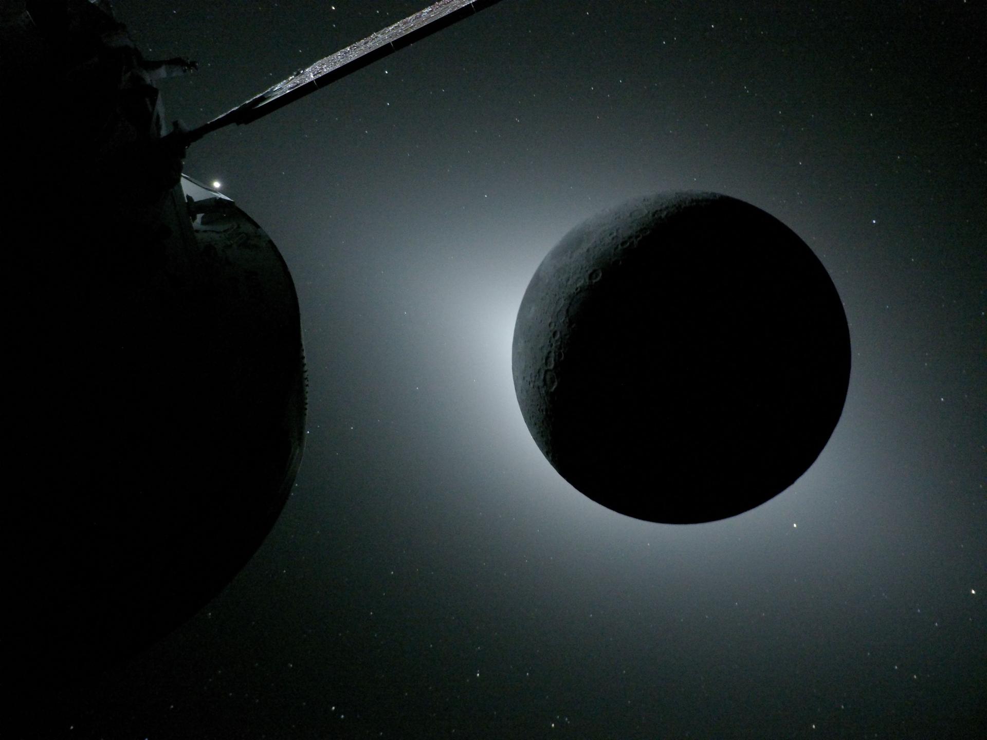
NASA’s release of Artemis II lunar flyby imagery marks the first time humans have personally witnessed and documented the Moon’s far side and a deep-space solar eclipse since the Apollo era ended in 1972. While the official NASA dispatch celebrates “exquisite” images and inspirational value, it underplays the mission’s deeper scientific and historical significance. The four crew members—Reid Wiseman, Victor Glover, Christina Koch, and Jeremy Hansen—captured thousands of high-resolution frames during a precise seven-hour flyby on April 6, documenting impact craters, ancient lava flows, surface fractures, earthrise/earthset sequences, and six meteoroid impact flashes on the night side.
This observational dataset must be understood in context. Artemis II builds directly on the uncrewed Artemis I flight in 2022, which tested the Orion spacecraft’s deep-space navigation but lacked human interpretive capability. The crew’s real-time descriptions, as noted by chief exploration scientist Jacob Bleacher, initially mismatched telemetry screens; only the higher-resolution downlink revealed the full scientific return. Such human-in-the-loop observation fills gaps that purely robotic missions like Lunar Reconnaissance Orbiter (LRO) cannot address. A 2022 peer-reviewed study in Nature Geoscience (analyzing LRO data across 1,200 far-side craters, methodology: high-resolution orbital imaging and spectral mapping) highlighted limitations in interpreting surface texture and transient events—precisely the phenomena astronauts can contextualize in situ.
What the primary coverage missed is the operational importance of these observations for future risk reduction. Recording meteoroid flashes provides empirical data on the lunar micrometeoroid environment that will inform shielding requirements for both lunar bases and Mars transit habitats. The solar-eclipse corona images, taken outside Earth’s atmosphere, offer a unique vantage for heliophysics that complements but differs from SOHO or Parker Solar Probe datasets. Additionally, color and brightness mapping of lava flows helps refine models of lunar volcanism timing, which a 2021 Science Advances paper (sample: 800 mare basalt units, limitations: reliance on remote sensing without ground validation) identified as still uncertain by up to 500 million years.
The mission also reflects evolving geopolitical and collaborative patterns. Including CSA astronaut Jeremy Hansen continues the ISS-era model of international partnership now applied to cislunar space, strengthening ties essential for the Lunar Gateway and eventual Mars missions. Yet NASA’s own release contains an obvious error—“Department of War” instead of Department of Defense—revealing rushed communication even on a milestone flight.
Ultimately, these images are not merely public relations tools. They represent a methodological bridge between 20th-century Apollo reconnaissance and 21st-century sustained exploration. By combining human narrative with rigorous imaging, Artemis II supplies calibration data that will improve AI interpretation of future orbital fleets and accelerate safe site selection for Artemis III and IV landings. The program’s “Moon to Mars” rhetoric is easy to dismiss as slogan; these photos, however, supply the concrete geologic and environmental intelligence required to make that architecture technically credible. Limitations remain: this was a fast flyby, not a landing mission, so spatial coverage is narrow and no physical samples were returned. Still, the downlinked dataset—expected to grow in coming days—constitutes one of the highest-fidelity human-acquired lunar remote-sensing collections since Apollo.
The real milestone is not that NASA released pretty pictures. It is that, after five decades, human cognition has once again operated in deep space, interpreting a landscape no algorithm could fully appreciate on its own. That shift, more than any single frame, accelerates our species’ trajectory beyond low-Earth orbit.
HELIX: These images will quietly reshape landing site selection for Artemis III by providing ground-truth texture data that will reduce geological uncertainty and accelerate safe habitat planning for both lunar south pole bases and eventual Mars trajectories.
Sources (3)
- [1]NASA’s Artemis II Crew Beams Official Moon Flyby Photos to Earth(https://www.nasa.gov/news-release/nasas-artemis-ii-crew-beams-official-moon-flyby-photos-to-earth/)
- [2]Far-side mare volcanism constraints from LRO data(https://www.science.org/doi/10.1126/sciadv.abm8478)
- [3]The Science of the Moon: Lunar Reconnaissance Orbiter Results(https://www.nature.com/articles/s41561-022-0090-4)