US-Indian NISAR Mission Reveals Mexico City’s Sinking Crisis, Highlighting Global Urban Challenges
The NISAR mission, a US-India collaboration, has mapped severe subsidence in Mexico City, revealing sinking rates over 2 cm/month due to groundwater extraction. Beyond technical success, this data highlights urban inequity, ecological loss, and global potential for space tech to address climate-driven infrastructure crises often ignored by mainstream space narratives.
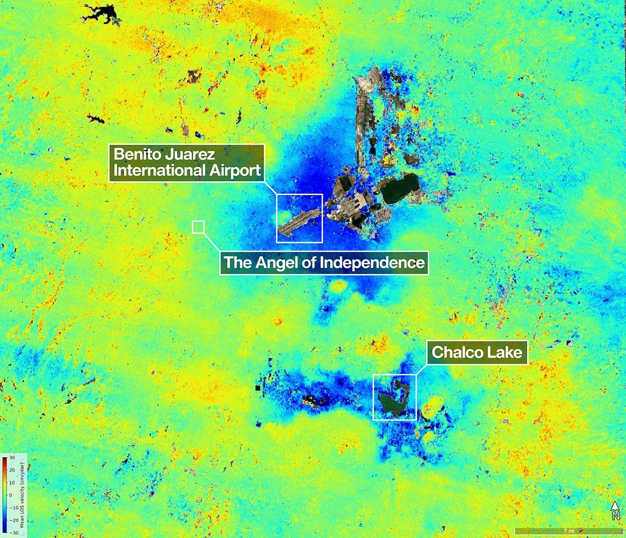
The recent data from the NASA-ISRO Synthetic Aperture Radar (NISAR) mission, launched in 2025, has provided a striking visualization of land subsidence in Mexico City, capturing rates of over half an inch (2 centimeters) per month in some areas between October 25, 2025, and January 17, 2026. This map, generated using NISAR’s dual L-band and S-band radar instruments, confirms the city’s long-standing battle with sinking ground, primarily due to excessive groundwater extraction compacting the ancient lakebed beneath. While the primary source from NASA highlights the technical success of NISAR in its first year, it skims over the broader implications of this data for urban planning, environmental justice, and international collaboration in addressing climate-driven infrastructure crises—a gap this analysis seeks to fill.
Mexico City’s subsidence is not a new phenomenon; studies dating back decades have documented rates as high as 15 inches (38 centimeters) per year in the 20th century, though mitigation efforts have slowed this in some areas. The NISAR data, with its unprecedented precision and global coverage, offers more than just confirmation of a known issue—it provides a tool for real-time monitoring that could inform policy. The dark blue zones of rapid subsidence in the imagery correlate with densely populated, often lower-income areas where groundwater pumping remains a critical water source due to inadequate infrastructure. This raises questions of environmental inequity that the original coverage overlooks: who bears the burden of sinking land, and who benefits from the data NISAR provides? The Angel of Independence, a cultural icon noted in the NASA report, has literally been elevated by 14 steps over time to counter subsidence—a poignant symbol of adaptation, but one that masks the struggles of millions living in less visible, more vulnerable neighborhoods.
Beyond Mexico City, NISAR’s capabilities—combining NASA’s L-band radar for penetrating dense vegetation and ISRO’s S-band for finer agricultural monitoring—position it as a game-changer for urban and environmental challenges globally. The mission’s ability to deliver rapid, detailed data before and after disasters could revolutionize response strategies in cities facing similar subsidence issues, such as Jakarta, which is sinking at rates of up to 10 inches (25 centimeters) per year, or Venice, where sea level rise compounds land settling. Yet, the original source misses this broader context: NISAR isn’t just a technological triumph but a case study in international collaboration addressing problems that transcend borders. The US-India partnership behind NISAR, forged amidst geopolitical tensions elsewhere, underscores how space technology can unite nations around shared climate and infrastructure threats—a narrative often drowned out by media focus on competitive space races or Mars missions.
What’s also absent from the initial reporting is the ecological toll tied to subsidence. The NASA piece mentions marshy remnants like Nabor Carrillo and Chalco Lake, tied to the drained Lake Texcoco, but fails to connect this to biodiversity loss. The Mexican Axolotl, an endangered salamander native to these wetlands, faces habitat destruction exacerbated by subsidence and water extraction. NISAR’s data could indirectly support conservation by mapping wetland changes, yet this potential application remains unexplored in mainstream coverage. Additionally, the ‘noise’ in the data—yellow and red zones flagged as artifacts—deserves scrutiny. While NASA anticipates refinement with more data, this limitation suggests early findings should be interpreted cautiously, especially for policy decisions.
Methodologically, the NISAR data stems from radar interferometry, comparing surface changes over time with a sample size limited to the temporal window of three months. This short duration, while impressive for early mission validation, restricts long-term trend analysis—a limitation not highlighted in the original piece. Compared to ground-based studies, which often involve thousands of measurement points over years, NISAR’s strength lies in its broad spatial coverage rather than depth of historical data. As a non-peer-reviewed update from NASA’s photojournal, this source also lacks the rigorous scrutiny of academic publication, though its technical claims align with prior SAR mission validations.
Synthesizing additional sources, a 2021 study in Nature Geoscience on global subsidence hotspots (doi:10.1038/s41561-020-00676-z) estimates that 1.2 billion people live in subsiding urban areas, with groundwater extraction as the primary driver—a scale that contextualizes Mexico City’s plight. Meanwhile, ISRO’s own reporting on NISAR (via their 2025 mission updates) emphasizes its agricultural monitoring potential, suggesting applications beyond urban subsidence to food security in water-stressed regions. Together, these sources paint a picture of NISAR as a multi-faceted tool, one whose value lies not just in mapping sinking cities but in addressing interconnected crises of water, food, and habitat loss—connections the primary NASA article underplays.
In sum, NISAR’s Mexico City data is a window into a future where space tech tackles gritty, ground-level problems. It’s a reminder that the most pressing space missions aren’t always about distant planets but about saving the ground beneath our feet. If harnessed with equitable policies, this US-Indian collaboration could redefine how we confront urban climate challenges—provided we look beyond the pretty pictures to the people and ecosystems at stake.
HELIX: NISAR’s early data on Mexico City subsidence could spur urgent urban water policies if paired with local action, though equitable implementation remains a hurdle.
Sources (3)
- [1]US-Indian Spacecraft Captures Mexico City Subsidence(https://science.nasa.gov/photojournal/us-indian-spacecraft-captures-mexico-city-subsidence/)
- [2]Global mapping of urban subsidence hotspots(https://www.nature.com/articles/s41561-020-00676-z)
- [3]ISRO NISAR Mission Updates 2025(https://www.isro.gov.in/missions/nisar-updates)