Super El Niño 'Freight Train' Accelerates Climate Disasters as Political Inaction Downplays Looming Crises
A potent El Niño plume racing across the Pacific could produce one of history's strongest events by late 2026, triggering floods, droughts, record heat, and other extremes. This highlights how mainstream narratives and political inertia frequently minimize interconnected climate emergencies driven by both natural cycles and human warming.
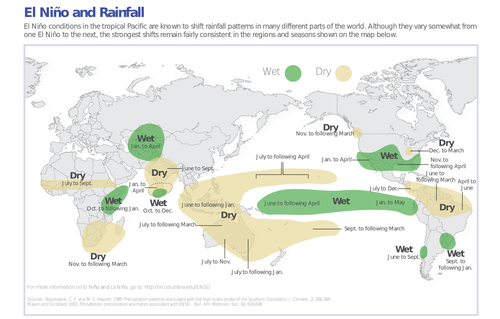
Meteorologists tracking Pacific Ocean temperatures are sounding alarms over a powerful subsurface plume of warm water advancing eastward 'like a freight train,' with ECMWF models projecting anomalies reaching +3°C by November 2026 in many scenarios. This suggests the developing El Niño could rank among the strongest on record, with Ben Noll and Ryan Maue highlighting record-breaking warmth in some equatorial zones peaking near 7°C above average. While such events naturally redistribute global heat and moisture, the rapid escalation coincides with anthropogenic warming, amplifying risks of widespread flooding in the southern U.S. and parts of South America, severe droughts and wildfires in Australia, Indonesia, and the Amazon, and further spikes in global temperatures.
Mainstream coverage often frames this as seasonal variability with some benefits, such as suppressed Atlantic hurricane activity due to increased wind shear. However, this perspective downplays the urgency: a 'super El Niño' layered atop decades of accumulated greenhouse gases could push 2026-2027 toward record heat, exceeding 1.5°C thresholds temporarily and exposing vulnerabilities in global food systems, water resources, and infrastructure that political cycles consistently deprioritize in favor of short-term economic or partisan battles. Connections frequently missed include how stronger El Niños in a warmer baseline climate may intensify feedback loops—marine heatwaves, altered jet streams, and extreme precipitation patterns—not seen in historical events like 1997-98 or 2015-16.
Credible forecasts indicate this event differs due to the elevated background temperatures from fossil fuel emissions, potentially driving crop failures, mass migration pressures from affected regions, and economic losses far beyond typical weather insurance models. The good news of fewer Atlantic storms masks broader systemic threats, underscoring how environmental signals like this subsurface 'code red' are sidelined amid governmental inaction on emissions and resilience building. As the plume builds through summer 2026, the window for proactive measures narrows, revealing a pattern where climate crises escalate faster than institutional responses.
LIMINAL: This super El Niño will likely expose the dangerous gap between accelerating climate signals and political paralysis, compounding disasters in ways that mainstream optimism consistently underestimates.
Sources (5)
- [1]Are we heading for 'super El Niño' – and what could it mean?(https://www.theguardian.com/environment/2026/apr/13/el-nino-explainer)
- [2]Is a Super El Niño Coming in 2026? Here's What Scientists Say(https://time.com/article/2026/04/10/super-el-nino-2026-what-to-know/)
- [3]State of the climate: Strong El Niño puts 2026 on track for second-warmest year(https://www.carbonbrief.org/state-of-the-climate-strong-el-nino-puts-2026-on-track-for-second-warmest-year/)
- [4]Super El Niño: What it could mean for US weather, global heat and daily life(https://www.accuweather.com/en/climate/super-el-nino-what-it-could-mean-for-us-weather-global-heat-and-daily-life/1880544)
- [5]Rare triplet cyclones could have global impacts, boost chances for El Niño(https://www.washingtonpost.com/weather/2026/04/03/rare-triplet-cyclones-explained-el-nino/)