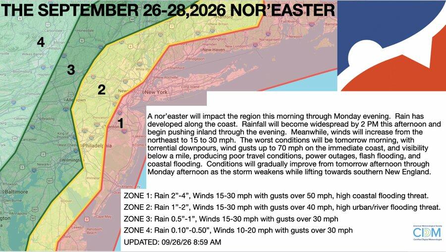
Nor'easter Produces 62 MPH Gusts and Coastal Flooding from Delaware to Massachusetts
The nor'easter produced measurable coastal flooding and power loss across four states with peak gusts of 62 mph. Infrastructure response depends on pre-positioned mutual aid rather than federal declarations. No hurricane activity has occurred in the Atlantic basin to date.
The storm tracked along the East Coast with sustained northeast winds of 15-30 mph and coastal gusts exceeding 50 mph in multiple locations. National Weather Service reports documented 58 mph at Bethany Beach, Delaware, 55 mph at Chatham, Massachusetts, and 53 mph at JFK Airport, with high tides expected to repeat flooding through Sunday evening.
Power outage data from utility trackers showed immediate concentration in coastal New Jersey and New York counties where wind and surge overlapped. Rainfall totals reached 2-4 inches in the primary impact zone, producing urban and river flooding separate from the tidal component.
El Niño wind shear has kept Atlantic hurricane formation at zero through late September, shifting seasonal risk toward extratropical systems that still test coastal infrastructure and evacuation capacity. State emergency declarations and utility mutual aid agreements determine the speed of power restoration more than the storm's absolute intensity.
Conditions are forecast to improve after Monday as the low lifts northeast, but repeated high-tide cycles will continue minor flooding until the system fully departs southern New England.
National Weather Service: Total power outages will remain below 150,000 by Monday evening as the system weakens.
Sources (2)
- [1]Primary Source(https://www.weather.gov/)
- [2]Supporting Source(https://poweroutage.us/)